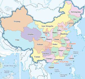
Map of provinces and cities in China
The People’s Republic of China, referred to as China, is a socialist state under the people’s democratic dictatorship led by the working class and based on the alliance of workers and peasants, located in the eastern part of Asia on the west coast of the Pacific Ocean.
Established on October 1, 1949 (Ji Chou Year), with the five-star Red flag as the national flag, “March of the Volunteers” as the national anthem, the national emblem includes the national flag, Tiananmen Square, gear and wheat and rice ears, the capital Beijing, the provincial administrative region is divided into 23 provinces, 5 autonomous regions, 4 municipalities directly under the central government, 2 special administrative regions, is a Han nationality as the main ethnic group, A unified multi-ethnic state composed of 56 ethnic groups.
After the founding of New China, it immediately carried out economic recovery and construction, began three major transformations in 1953, and established the socialist system in 1956, entering the stage of socialist exploration. Reform and opening up began after the Cultural Revolution, and the socialist system with Chinese characteristics was gradually established.
China has a total land area of about 9.6 million square kilometers, over 18,000 kilometers of mainland coastline, over 14,000 kilometers of island coastline, and over 4.7 million square kilometers of inland and border seas. There are more than 7,600 islands in the sea area, of which Taiwan Island is the largest, covering an area of 35798 square kilometers. It has borders with 14 countries and maritime borders with 8 countries.
China is one of the four ancient civilizations with a long history and culture. It is the world’s third largest country in land area, the world’s second largest population country, and Britain, France, the United States, Russia and the five permanent members of the United Nations Security Council.
Map of China
